
Paksé, Laos. Wednesday 15th August, 2018.
On the second day after leaving Phnom Penh, I entered Laos. The ride up had been interesting. I passed through scenery that I hadn’t seen before. It was completely dominated by the river and surrounding wetlands. The roads were raised on causeways across the water. Houses, indeed whole villages, were on stilts, usually with a long tail boat or a canoe moored outside, in lieu of a motorbike. Cattle where tethered at the side of the road, munching on feed stored in mini haystacks, there being nowhere for them to graze. The water level was very high, it still being the rainy season. At times I saw buildings in the fields, submerged up to their roofs. It demonstrated just how much the seasons affect daily life in these areas.
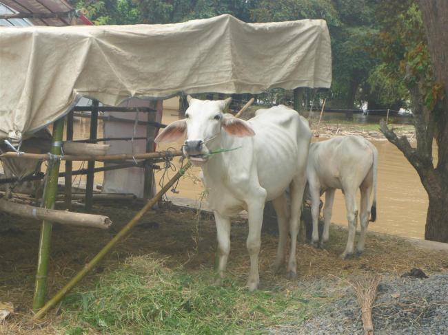
Bovine Beauty in the wetlands.
As I passed through one particular town town the GPS took me along a back road. I passed a half hearted no entry barrier, which I ignored. Just where the road rejoined the main route I came to a kind of marquee that was open at the sides and straddling the road. I rode through and the people sitting at the tables off to one side gave me a cheery wave and a smile as I passed by. Now I understood the no entry signs. Fortunately the event they were attending had yet to start. Maybe I should have stopped to join in.
After a night in Stung Treng, in the same hotel that I stayed in last time, I headed for the nearby border. The last 25kms were on a road that had deteriorated into muddy, potholed hell. And it was raining too. Fortunately it improved towards the end. I can never quite make out why some countries neglect these border roads so much, especially as this was the only land crossing between the two countries.
Cambodian immigration insisted that I go over to Laos to make sure they would let my bike in, ahead of them stamping me out. The usual common sense from them. There was a helpful young guy who came over with me in case of any difficulty. Laos customs were more than happy to use my Carnet so Cambodia immigration happily stamped me out. Back over on the Laos side I was filling out the immigration paperwork when the young guy came back over to me and told me, very firmly, that I needed to back to his side so that Cambodia customs could stamp my paperwork. I said OK, meanwhile thinking that I didn’t actually have any paperwork. I’d bribed my way into Cambodia and fixers don’t issue forms. What to do? If I went back over I knew there’d be hassle and that it would cost me dollars. So I did the sensible thing and, once I’d got my visa, carried on into Laos. After all, I had no plans to return to Cambodia and there was nothing he could do. While I think of it, and in case you wondered, ‘Laos’ happens to be pronounced like ‘cow’.
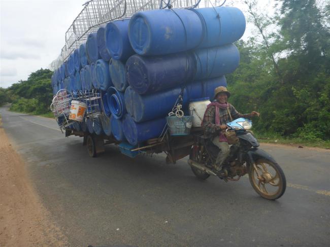
None of these happy hauliers in Laos.
The contrast between the two countries was immediate. Very few people, not much by way of housing or villages. The people I did see were often walking and looked very scruffy and careworn. Ethnically they were the same, economically very different. Clearly Laos was a much poorer and less populated country. This was confirmed during a conversation I had with someone later. Laos is bigger than Cambodia at 236,000 sq kms compared to 181,000 sq kms. In complete contrast the population density of Laos is 29 people per sq km, whereas Cambodia’s is 82. It’s no wonder it was eerily quiet.
I headed to Paksé, the first major town up the line going north. I needed to do two things. Buy a new horn to replace the one that fell off on the rough border road and find a bed for the night. Both were easy to do. The bed was in a hostel on the main road. I’d already found a bank where I could change some dollars into Laos Kip. I could now pay for that bed and also food and beer. Equally importantly, a SIM card as well. Paksé was just a stopover place and next day I rode on north to Thakhek. I’m always interested to see what vehicles I’m sharing the rod with. Bearing in mind this is the only road between two countries, I was surprised at how quiet it was. There were a fair number of trucks though, probably the reason for the rough patches of asphalt I kept coming across. They were mostly articulated, or rigids towing a close coupled trailer. Both of them quite rare in SE Asia, especially the latter. The artic units were bonneted American trucks, or Asian copies. The bikes I saw tended to have a sidecar attached, rather than tow a trailer. I’d last seen that in Thailand. I didn’t see any of them towing trailers at all, in fact. Tuk tuks were the standard three wheel type, rather than bikes towing a ‘carriage’. The most common road users were animals. Lots of them. Cattle, goats, pigs, chickens and ducks wandered around at will. They seemed to understand the nature of traffic and did what is often said to people to be the best thing to do – head across the road, don’t divert and let the traffic work around you. I feel that pretty much any vehicle will happily give way to two tonnes of water buffalo! I’m very pleased to report, thinking back to my experience on my first day in Cambodia, that the dogs seem to have some road sense too. But not the goats. Oh no! They would happily run across the road without a thought for my safety. Typical kids, really.
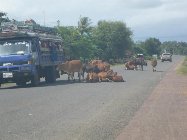
Animals seemed to own the roads here.
Thakhek is much more tourist orientated and is famous for the Thakhek Loop. This is a 450km circular road trip, best done on a motorcycle, although hardy types tackle it on bicycles too. The hostel I stayed in also rents out bikes and provides a map of the loop and, along with some internet research, I made some plans. But I’ll come back to that. It was also down by the Mekong and it felt a bit strange, as I walked along the river that evening, to realise that the lights on the other bank were in Thailand. The contrast between the two countries is huge in terms of economic development and their politics. Laos is a communist state, Thailand a democracy. Dual carriageways and expensive 4WDs abound across the river, as against sandals and scruffy clothes on this side, in the rural areas at least. I guessed that the dearth of even cheap motorcycles was due to poverty. But Thakhek was a thriving town, with plenty of businesses supplying every kind of need. Talking of which, I was highly amused when, during one of my walks, a policeman chatted to me and took the trouble to tell me where I could find an unbelievably cheap prostitute. I thanked him politely and ‘moved along’.
Back to the Thakhek loop. This ride is promoted as being ideal for tourists who are keen to see the natural beauty of the area. It’s best to hire a scooter or bike and spend the minimum recommended time of three days exploring it. Better yet, it’s suggested, take four or even five. What on earth is there that would take so long? Caves, mostly. The southern part of the loop runs through an area of karst limestone. This porous rock gets eaten away by rain and weather, at the same time allowing water to soak down through it. The result of this is caves, often with underground rivers running through them. There were quite a few of them I could see so I chose a couple of the nearby ones to visit during an afternoon out. I planned to ride the loop later and would visit other sites on the way. Not all of the caves were open because of high water levels and the same applied to some of the access tracks. My chosen two were Elephant Cave and Buddha Cave.
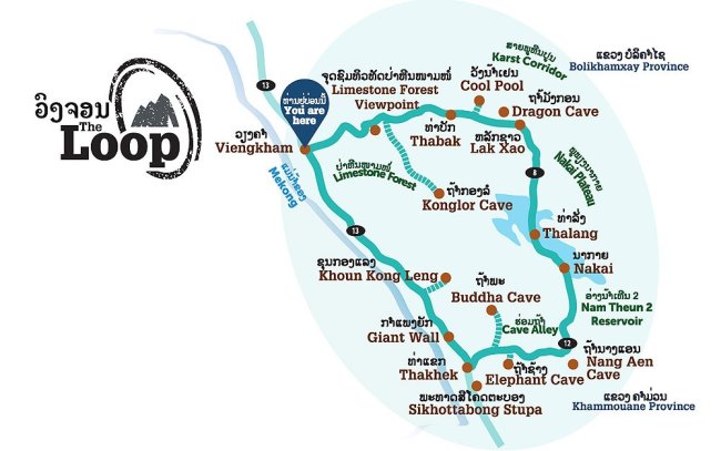
A map of ‘The Loop’, with plenty to see on the way round.
The story behind Elephant Cave is that it once contained a strangely shaped rock which frightened the locals. (Although Buddhism is the main religion, animism is still quite strong in Laos.) In 1956 they got brave and decided to blow it up. What was left of the rock now looked rather like an elephant. So that being much more to their taste, they installed shrines in there. Once I’d negotiated the muddy track down to it, and climbed up to the cave, I had to agree with them. It did look rather like an elephant.
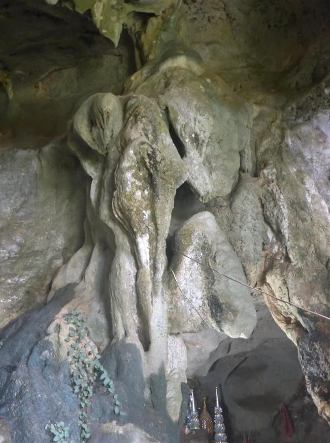
The resident rocky elephant.
Getting to the Buddha Cave turned out to be something of a self inflicted challenge. I turned off the road and up the track, but I missed the sign telling me to turn left. Pretty soon I came to a place where there had clearly been a landslip of some kind. The locals were there, trying to clear the track and create a through route by laying down rocks. They helpfully directed me through the mud and then over a ford, across a fast flowing stream. None of them thought to ask me where I was going and I didn’t think to check the route with them. The result was that I rode several kilometres further up the track before checking the map. That was when I realised I’d needed to turn left further back. I’d seen a track going off, so I went back down to it and followed it. When I reached a small village next to a lake, with the track going no further, I realised my mistake. Back I went, down across the ford and through the mud once more.


My attention was drawn to the myriad of stalls selling snacks and drinks to the willing workers, suggesting this operation was a longer one than just a bit of clearing up. This time I took the correct turning and found the access point to the shrine. It was a very strange place. There was a small lake off to one side, with some buildings stood in the water, including a small temple. The entrance to the shrine itself was across another small lake which had a submerged walkway on one side of it. Therefore access was by canoe. Unfortunately I had no small notes and they had no change so I had to abandon my visit and leave it for another day.

On a sunny day this scenery can be very beautiful.
I didn’t head straight back. Instead I carried on further along the loop route, just to see what was there. The most striking feature was the landscape, which clearly had once been a massive limestone escarpment. Now,following of millennia of erosion, the tree covered remnants looked more like nature’s tribute to bad dentistry. Misshapen hills with large gaps between them. But leaving aside that image, I could see deep green trees climbing up the steep hillsides with most of the detail lost in the haze. I took some photos, but not many. Experience had taught me that hazy hillsides invariably just look dull.
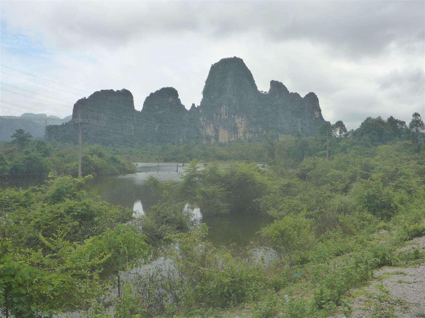
Nature’s tribute to bad dentistry.
That evening I met my friend Dave, from Thailand, and his wife Lesley, who were on a mini tour in Laos. We had a great evening, with nice food. Dave brought me up to date with his travails regarding the German camper truck. He’d almost got it through Thai customs but they decided that because the carnet wasn’t in his name, it couldn’t go. So it was stuck at the border. Dave knows some officials in Thailand and was confident he’d get it sorted out in the end. We went for a walk next morning and were surprised to find a ferry terminal, although it was clearly for local use only. Foreigners would have to use one of the two (or it may possibly be three now} Friendship Bridges that span the Mekong between the two countries.
I took a second ride out to the Buddha Cave, with some smaller notes in my wallet this time. It was delightful to see so many families enjoying their Sunday leisure time in the water alongside the track. The wet season clearly brings some advantages with it. Up at the cave I waited for the canoe to return from the other side but when it did the guy jumped on his bike and zoomed off. The water around the cave was a bit lower this time so I decided to clean my riding boots by wading across the walkway. It was about 150 metres each way and I was very pleasantly surprised when the boots didn’t let in a single drop of water.
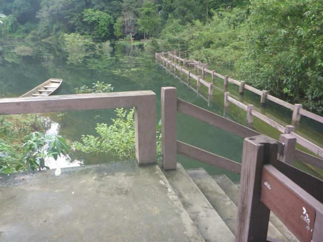
A submerged walkway and non-leaking boots. Who needs a canoe anyway
The story behind this cave is something of a mystery. In 2004 a local man saw some bats flying out of a hole in the cliff. Being partial to roast bat, he climbed the fifteen metres up to it and discovered a large cave containing 237 Buddha figures lined up on the rock shelves. They vary from 15cms to a metre high. Nobody knows when they were put there, or by whom, but it isn’t hard to imagine the reverence Laos feel for this place. Whether or not he caught any bats isn’t mentioned. The Buddhas looked nice, and I thought the small ones were quite cute, but what really drew my attention was the geological beauty. There were some simply stunning stalactites in the cave, both of the pillar and the curtain variety. Some were twisted around each other, reminding me of a Rastafarian dreadlock; the curtain ones were just stunningly beautiful and there was plenty of them to admire. The rock formations were great too, and I was amazed by the way the limestone had other rocks trapped within it. But there was only one problem. Visitors aren’t allowed to take photos, and there were too many local people laying around in there for me to be able to sneak any. What a shame.
I finally left Thakhek to ride the rest of the loop. There’s another well known cave along the southern section, called Nang Aen. Visiting this involved a two kilometre underground boat trip, past stalactites etc. But I’d read in somebody’s blog that it was too commercialised, with an excess of LED lights illuminating the cave. I decided to give it a miss as I had an alternative, and better cave in mind. The same blog advised of a side route, off the main loop, which had involved the writers in travelling some dirt roads on their scooters, crossing one river in a canoe, and a couple of others via fords. It sounded like fun but a note of caution crept in. They had completed this ride in February, during the dry season. I was riding during the wet. What would these tracks be like? Well, I found the answer to that question after I’d turned off, gone through a village on a nice, sealed road, then had crossed a bridge and straight into thick mud. I wasn’t surprised. I didn’t fancy battling it for 30kms or so, only to find the fords impassable and have to backtrack. So I did the sensible thing and turned round. There’s no shame in that but at least I’d given it a try.

I saw this ex-US Army truck while on my little diversion. Most likely used for logging now.
As I headed up the eastern side of the loop, heading north, I was very taken by the scenery. The tree covered limestone hills were looking gloomy and seemed to be frowning down on the vehicles wending their way along the road. Some of them wore clouds as a hat but I was pleased to see them being chased away by the sunshine as the grey morning gave way to brighter weather. There had been plenty of trucks heading from Thakhek towards the Vietnamese border, due east of the town. But this section was quieter and in better condition, with no heavy trucks to tear up the road surface.
Before long I came to the visitor centre for the Nam Theun 2 Dam. I stopped for a look and was fascinated by the information there. The dam serves a huge hydro-electric system and the VC was full of information about the building of it, how it operates and its effect on local people.The engineering was carried out by the same company as built the Snowy Mountain plant, in Victoria, Australia. The VC was near the generating plant. The dam itself was much further up the hill and caused the Nakai Plateau to be flooded. To me the most interesting part of the display was the effect on the people. They were consulted about the plans and, for the most part, became very excited about them. Although they would lose their traditional land on the plateau, they would be moved to newly built villages, with electricity and much better housing and facilities, including schools and health clinics. They were each to be given a personal plot of land of 0.66 hectares, and would have communal farmland too, same as before. Best of all was that when the dam was finished they would have exclusive fishing rights for the new reservoir. What was the outcome? Very good, according to the information given. People were much better off and some of the key measures relating to poverty improved hugely. Infant mortality and primary school attendance being two of them. A good news story then.

The official version, largely true I suspect.
In terms of electricity production, the plant puts out over 1,000 mega watts, some of which is exported to Thailand. Laos declares that it wants to be the ‘battery of SE Asia’. To this end it is building another dam further south and it was this project that was in the news recently when an overspill dam burst and caused severe flooding near the town of Attapeu. It isn’t all sweetness and light, it seems. The other issue is the effect on areas, and people, further downstream. Altering the flow rates of rivers can have a severe impact on the normal seasonal water levels and the crops that rely on them. But of course, none of this is mentioned in publicity displays and I haven’t taken the trouble to look into whether there actually is an adverse effect, so maybe I’m being unfair.
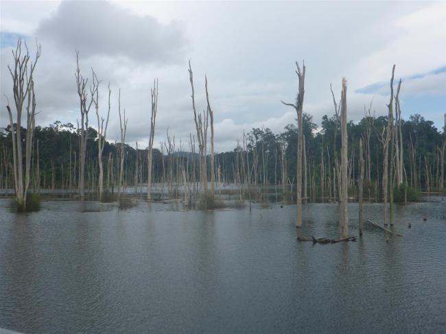
Sentinels from the past.
The road climbed upwards and before long I was riding across the reservoir on the new road and its causeway. The villages I passed through did look prosperous but the most striking sight was the reservoir itself. As I rode across it I could see hundreds of small, green islands, tree and scrub covered, poking through the water. Clearly they used to be small hills, the bulk of which were now submerged. The most eerie sight was of the tree trunks, devoid of foliage, but poking up through the water, like sentinels to the past. The photo of my GPS screen helps to paint the picture of how it looked, with the road constantly crossing bridges as it wound its way through the plethora of islands.
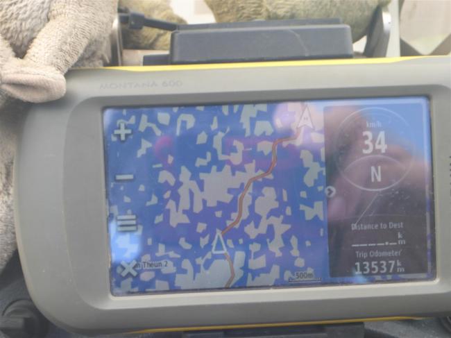
Thousand islands, guessing.
I made my way from the main road down to the highlight of the trip, Konglor Cave. After a night in the Konglor Ecolodge I walked down to the river. I was asked to wait for thirty minutes to see if anyone else turned up who could share my canoe. This is normal so as to reduce the operator’s costs. A Korean man and his son came along so off we went. We got into a canoe that was paddled towards the cave entrance. I was puzzled because I could see that as the river exited the cave it went over a small drop and was swirling around at high speed. How was our boatman going to get us through that maelstrom? He didn’t actually try to, I’m pleased to say. Instead he paddled us across the river where he beached the canoe. Then we climbed over some rocks and into the cave itself. There we got into a bigger canoe powered by a long tail engine and propeller. The engine is mounted on the back of the canoe but the propeller shaft is 2-3 metres long and enters the water at a shallow angle well behind the canoe. This design is common on these river systems, which are often quite shallow. We set off into the darkness, our supplied head torches illuminating the cave walls and roof. Soon we pulled onto a sandy beach and were directed to walk up some steps. Our guide tried to switch on some lights but they wouldn’t work, so we walked along the path checking out the stalactites and rock formations by torchlight. Back in the canoe we motored on, through tunnels and caverns until we emerged on the other side. There was a place where we could get snacks from a woman who was busy weaving cloth on a hand loom. Her cat was quite happy to share my packet of crisps. Is that normal?


Fitter people had the opportunity to rent a bike and cycle off down the cycle trail through the valley, before coming back for their return boat trip. We just had a rest before making the return journey. We stopped at the stalactites again and this time the lights were working, enhancing their natural beauty with some subtle effects. By the time we got back we’d travelled fourteen kilometres underground. The roof of the caves never came down really low, nor did the passages get really narrow. But some of the caverns were cathedral-like vast. Completely unable to detect the roof at times. It’s quite amazing what water can do, given enough time and a decent supply. I was enormously impressed by our boatman’s ability to navigate through the system. I imagine that a wrong turning could lead to a life as a troglodyte.


The ride back to the main road was extremely enjoyable. Mostly straight, it drove across paddy fields that lay between the river on one side, and karst limestone escarpments on the other. The rice in the wet fields was ripening nicely and presented itself as an emerald green carpet spreading across to the escarpment, itself a much darker green. The sun was out and visibility was good. Wisps of cloud wrapped themselves around the hill tops, as if they were wearing a scarf on a chilly day. Perfect.
Eventually I joined Route 8 and turned west towards Vientiane, Laos’ capital. Behind me the road also ran east to the Vietnamese border so was busy with trucks. The problem was that it wasn’t a very good road. It climbed quite steeply up into the hills and a steep road inevitably means sharp bends. The trucks tore up the surface as they went round, so making their own life very difficult. More than once I came across queues of trucks stuck on a bend as they fought to get round and up, across the damaged surface they themselves had created. I just picked my way through them and carried on. Road maintenance doesn’t seem to be a big thing here. It’s as if they’ve built the road and then just left everyone to it. To be fair, Laos is the ASEAN area’s poorest country. But on the way down from the hills I came unstuck. I wasn’t going very fast but too fast to see a large pothole in front of me. I braked hard and tried to swerve round it but the front wheel locked up and down I went. No injuries to me, some minor damage to the bike. The main thing was a couple of broken straps on the front and rear RH panniers. Some repairs would be necessary.

Riding back from the caves through stunning scenery.
Those repairs were carried out that evening once I’d found a hotel. Across the road was a restaurant, which also advertised Family Karaoke. I’d seen this sign before and had wondered exactly what it meant. I soon discovered the answer. A group of about ten people were sat at a table. It took me while to work out what was happening, but I eventually saw that the TV screen was sited in front of them and they took it in turns to screech and caterwaul in the time honoured tradition, without having to even stand up. Asians are tolerant people. I thought it just as well. Fortunately they were in another room. There was also a karaoke bar next to my hotel, in full swing by the time I got back. Luckily they didn’t stay open too late.
As I rode into Vientiane I was impressed. The city has wide boulevards, traffic that obeys road rules and some nice looking buildings. But where were the motorbikes? Yes of course there were some around, but no sign of the million motorcycle madness I expect in Asian cities.. Those that I did see stopped at traffic lights, used indicators and generally behaved themselves, whereas I was used to them ignoring red lights and coming at me from every direction. How odd. I quickly found a hostel to stay at and made myself comfortable.
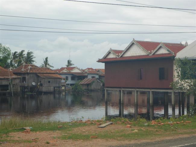
Villages on stilts. Essential to life in the wetlands.

Traditional fishing methods are still used here.
