
Hue, Vietnam. Saturday 6th October 2018.
I was torn. Should I stop and explore Hue and the nearby war history? Or should I continue north to see what goes on during the rice harvest? With my friend Peter advising me that the harvest was nearly over, and with talk of the rainy season approaching in the north, I decided to move on. Missing out on history, as I’m sure you’ve all noticed by now, isn’t really my thing. But I had a cunning plan! Think back to when I sneaked across the border and avoided customs. I believed that adopting the same approach when I left would be the best way to avoid awkward questions. To that end I planned to leave via the the same border crossing, which lay a little further south, and over to the west, from Hue. Therefore I’d be able to come back to Hue, and its history, later.
To that end I only spent one night there, having found a very nice hostel in the backpacker area, where the delightful young female staff made me feel very welcome. This is a common occurrence and I’m sure they feel they’re welcoming their grandfather, or something. They directed me to a café where I could get the local delicacy, Banh Khoui. This is a thin rice pancake, folded over and stuffed with egg, shrimps and pork, served with some salad. They looked small so I ordered two. They were delicious, so I had a third! As I walked around the town I was approached by at least six motorcycle taxi riders and offered weed and women. Did I look that needy? I declined and walked on. Being a Saturday night the streets in the backpacker area were closed to traffic. There was a nice atmosphere around, with plenty of people enjoying the food, drink and fun that was on offer. I was very much looking forward to coming back.
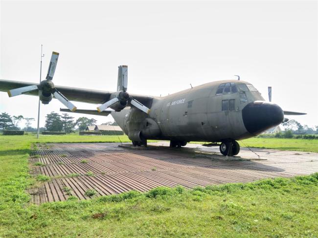
Abandoned C32 transport pla
It was from here that I headed west and picked up one of the routes recommended on the Vietnam Coracle website. The Ho Chi Minh Highway is a road that runs from Saigon to Hanoi, but which lies to the west of the country, often very close to the Laos border. The main north/south route runs closer to the coast and is choked with trucks. Very much to be avoided whenever possible. The HCMH runs up through the farms, hills and jungles of the central highlands, which is almost perfect bike riding territory.
I stopped off at Khe Sanh and visited the former US combat base just outside the town. A massive place, it was shared by the ARVN (South Vietnamese Army) and the US forces. It lies just south of the DMZ (Demilitarised Zone) so was always in the front line. Set up in the early 1960s, it was frequently attacked by the PAVN and was finally abandoned in July 1968, cited as being too vulnerable to attacks. They took it over in 1972, although not as a military base.


There is a collection of aircraft to gaze at, and also of army hardware. Tanks, Armoured Personnel Carriers and artillery pieces are strewn around. A large Sikorski helicopter, and a smaller combat one, are sited near the museum, with a C32 transport plane sitting further away on the old airstrip. There’s lots of restored bunkers and trenches to walk around as well. It’s easy to see how big this base was, although it’s indicative of how pointless these places ultimately are when you see that most of the terrain is now used to grow coffee. The small museum houses weaponry and a collection of photos, mostly showing US forces suffering defeat at the hands of the PAVN and their Laos allies. The base is very close to the Laos border and was involved in bombing raids on that country too. I couldn’t help but feel sad while I gazed across the vastness of the former base, similar to the feelings I had when I gazed over the battlefields in Flanders. What was all that death and destruction for, in the end?

Helicopters left behind.
I had a place in mind to stay for the night, gleaned from Vietnam Coracle. Google reckoned about three hours riding, I had about two and a half hours of daylight left. Before long the road changed into a narrow, newly laid concrete track, which wound its way through the hills and small villages. As I went higher I left behind the cultivated lands and came more into the natural jungle. Even so, I still saw people foraging among the trees and bushes, although I had no idea what for. I often saw collections very thin sticks, about 150cms long, and totally stripped of bark at the side of the road. Clearly left out to dry, I guessed they would be used to make rattan sections, or for some other natural construction.
The saw toothed limestone karst hills caused the road to wander about a lot, but generally north. Steady riding and steady progress, getting stares from the adults and waves from the kids as I rode past. Beautiful scenery of green hills, misty valleys and tree choked ravines, usually with a fast flowing river coursing through them. With barely another vehicle to be seen, I felt like a lord riding through his domain. I may not have actually owned anything I passed, but I felt like I did. And yes, I did make it to the village and its guesthouse before dark.

Empty road, heading for the hills.
In the morning, after more of the same delightful riding, I entered Phong Nha Ke Bang National Park. This remote area is home to many rare animals, such as tigers, black bears and elephants. Similar to the protected area across the border in Laos, its biggest draw is the natural terrain dominated by the limestone karst hills. Beneath these hills lie hundreds of caves and grottoes, many of them extremely big. Latest mapping shows there to be 126kms length of accessible caves just within Vietnam. Many of them have been previous record holders for caves, such as depth and length of river, but it’s the Son Doong cave that is now considered to be the worlds largest. Discovered in 2009 by Vietnamese and British explorers, it is felt there is still more of it to discover. I have to say that I don’t really know how to go about measuring a cave. Length? Volume? Strength of echo? Number of bats? Who knows. But I can say, with certainty, that this part of Vietnam and Laos is likely to be the largest area of limestone karst anywhere. Think back to when I was in Laos and exploring the Thakhek Loop, quite a long way south and east of where I now was. I didn’t have time to explore the park so I pushed on, with thoughts of returning sometime.

I often saw these very thinly sliced wooden sections, drying at the roadside. But I have no idea of their purpose.
As I came into the park there was an official building of some kind, with people gathered around it. I stopped to say hello, hoping to get some information, but there was nothing much there. The youngsters I’d seen all got on their bikes and left, so I did too. Further along, right by a crossroads, I saw a few of the lads stopped at the side of the road. I needed to check my route so I stopped to look at the signs. One of them gave me a dried fish to eat, clearly the travellers’ staple in these parts. I ate it, then took a slug from the water bottle he offered me – and promptly spat it out! Even though I didn’t swallow any I could still feel its raw strength. Poteen, hooch or whatever, if that’s a common drink among the populace it would go a long way to explaining the standard of riding.

Dried fish (OK) and hooch (not so good).
I came to the town of Phong Nha, amused to see its name in big white letters at the top of one of the karst outcrops. I found some fuel for both me and the bike, noting the large numbers of backpacker hostels and tourists on scooters. Clearly the town acts as base camp for exploring the park. After my lonesome ride in the hills, it was strange to see so many people. What was stranger was how I managed to turn the wrong way when I left the town. Despite having both my GPS and Google maps to guide me, I managed to turn east instead of west. Pretty soon I was embroiled in the truck and dust hell of Route 1A, rather than the twisty, leafy peace of the HCMH. I turned back westwards as soon as I could, eventually regaining my narrow concrete haven.
Unfortunately I managed to bypass the last section of the hills. The highway was now flat but still very interesting. Harvest was in full swing. As well as seeing the rice stalks being cut and stood up in stooks out in the paddies, there was invariably some kind of crop laid out on plastic sheets at the side of the road. Nuts, sweetcorn, other unidentified produce, and the ubiquitous rice, often being raked over to help it dry by an old woman in a Chinese conical hat. The nearby modern vehicles notwithstanding, I had the sense this had been going on, in similar fashion, for centuries. When I stopped to take photos the friendly women were happy to smile and wave for my camera. It was wonderful.


My night time stop was at Tan Ky. Next to my hotel was a much bigger one with the odd name of Km 0. I discovered what this meant when I walked over to a memorial across the road. It also had Km 0 on it and marked the place where the infamous Ho Chi Minh Trail began. I was riding the Ho Chi Minh Highway, much of it newly surfaced and well signposted. The Ho Chi Minh Trail, by contrast, was now disused and, in many places, lost or destroyed. And most of it wasn’t even in Vietnam but in Laos, Vietnam’s friendly neighbour. The trail was developed during the First Indo China war, against the French, and didn’t fall out of use until 1975, when the war with the USA ended.
Very soon after leaving Tan Ky, the trail crossed the border before turning south. Its purpose was to allow PAVN troops, and their supplies, to move down to the areas occupied by South Vietnamese and American troops. It was never really just one trail. There were many parallel sections, and trails that branched off into Laos or back into Vietnam. Because of its military significance, the USAF bombed the crap out of it, often from the previously visited airbase at Khe Sanh. This action became known as The Secret War because the USA didn’t actually officially open hostilities with Laos. Measured on a per capita basis, Laos is the most bombed country in the world. But it was all pointless in the end because the ARVN kept up their activities despite the aerial disruption.

Ho Chi Minh Trail memorial at Kilometre Zero.
Further south, the trail was used to supply the Viet Cong, the nationalist/communist insurgents in the South of Vietnam. Supplies were sent south down the trail and brought in from Laos. It was difficult to get vehicles along it, firstly because of the state of the surface, but also because it was much easier for bombers to locate and destroy heavily laden trucks. So the most common method was the ‘pack bicycle’, a normal bicycle, adapted to carry supplies, and pushed along by determined people. Difficult to see and light enough to manoeuvre around damaged sections of the trail. If a section got destroyed it was a case of hacking a new route through the jungle, crossing rivers or ravines with bamboo bridges.
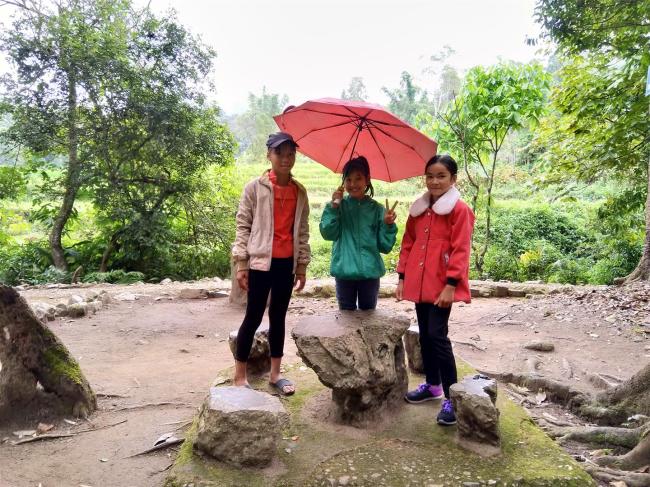
While I was looking at the memorial I got chatting to a couple of teenage girls. One of them spoke very good English and was keen to practice. As soon as I told them I was riding my own bike, they wanted to see it. After some photos they were keen for me to try some Bahn Goi, one of the local dishes. Across the street was an open air café where I tried this dish. My hopes sunk when I saw it was deep fried and they didn’t rise when I tasted it. A very bland, flat cake, filled with something indeterminate. It was, erm, very average. Teenagers only I suppose. I tried a couple of other things as I was hungry anyway. We parted company but I did keep in touch with the one who spoke good English, via messenger, for a couple of months. She’d ask my advice on cultural matters, obviously connected with her English classes. That was nice. I felt connected, which adds to the joy.

Friendly girls.
Over the next few days I made my way to the mountain town of Sa Pa, nearly 1,000kms of hills, harvesting and a fair degree of hassle. The countryside was the same mixture of low lying agricultural land, with the harvest still ongoing, and the hills I’d become used to over the previous few days. In this area harvesting is clearly a communal activity. Groups of people were laying out produce to dry and cutting down the rice stalks to build ‘haystacks’ for cattle feed. They’d carry the sheaves in from the paddy by putting a stick through the middle and putting it across their shoulders. The stalks were then put through a chopping machine. Water buffalo are common here and they’re left to munch through the rice paddies when they’re not pulling carts. But once the paddies have been replanted they have nowhere to graze so the stored food becomes essential. At one point I was riding through a wide valley and I could see, up ahead, a church spire nestling under the hillside. It looked very much like rural England and I saw several large churches in that area.


Up in the hills the effects of the rain were obvious, with the remains of landslips on, or at the side of, the road. Most of the hillsides looked very unstable but there were works going on to improve things. Much of the time I was following a fast flowing river, which had a couple of hydro-electric plants on it. The terrain often included the small, conical hills that I’d seen in various places. The result of volcanic activity. As I passed by one of the larger landslips I could see a layer of black earth between the layers of red. Volcanic ash from ancient eruptions.
As I went higher into the hills the ethnicity of the local people was changing. Darker skins, slightly different shaped faces and, for the women, a much different style of dress. In this part of NW Vietnam the weather is cooler and damper, often misty too. So warmer clothing was required and the women were now wearing heavy blouses and jackets. Long, decorative scarves were common, often worn as head coverings too. But the oddest thing was the change from the pony tail, ubiquitous across the lowlands and in the cities, to a large bun worn on the top of the head and often offset slightly to the left. What’s odd about that? It was the effect the bun had on the wearing of crash helmets. I couldn’t quite get over the way they would be perched on top of the bun, barely covering the side of the head, and with extra long straps in order to reach under the chin. But even odder than these were the few I saw which had an extra section set into the top of the crash helmet looking, at first glance, as if it had been moulded around a jam jar. The bun, I presume, fitted neatly inside it.


The hassle? In two of the towns I stopped at I was woken up at 5am by military style music blasting out from street-side loudspeakers, followed by some hup-two-three-four style exercise instructions. I looked out of the window, expecting to see the populace out in the street running on the spot. But no, just the damp asphalt and the occasional passing truck. I called into a café one evening, where they sold noodle soup. There were various meats and vegetables laid out on small, cling film wrapped trays. I pointed to a few, expecting to get some of each in the soup. Oh no, that was far too simple. I got all the contents of each tray I’d pointed at, spread across the table and with a huge bowl of boiling hot soup. It took a bit of doing, but I managed to eat all of it!


These weren’t really hassles, but when my silencer fell apart again, that certainly was. The end cover fell off one afternoon, but I carried on, albeit surprised at how loud it was. Next morning I realised the silencer had split, on the underside, almost from one end to the other. This was serious. I called at a couple of likely looking places in the town seeking a repair, but with no luck. In a town further along the route I spotted a couple of guys on a trail bike and struck lucky. They knew of a bike shop they thought could help, in the town of Son La, further down the line. They even rang up the shop to check they could help and then put me in touch with a friend in Son La, who could act as liaison should I need it.
I pushed my earplugs in firmly and made my noisy way there. I found the shop, and once they’d opened after lunch they agreed to give it a try. The silencer was aluminium, the inner section and the end cover were stainless steel, and it took over two hours of skilful TIG welding to get it all fixed up. All for a measly £10. I offered more but they wouldn’t take it. Surprised and delighted, I carried on, peacefully and quietly.


Next morning, after another session of marching band, I went into a café for breakfast and bumped into another traveller, a young Dutchman named Erwin. He was travelling around on a bike he’d bought and he told me of a place he’d stopped at en route. He said it was a viewpoint but when I got there it was actually a huge open air museum, the former headquarters of the forces that had driven the French out of Dien Bien during the independence war. As I walked into the complex three young girls took charge of me and walked around with me, not really showing me around but making sure I didn’t miss anything. They didn’t seem to want any money and I think their role was to make sure I took a route out of the area that passed by their family shop, selling snacks and souvenirs. I dutifully looked around but didn’t buy anything. Sorry girls!
My posse.
The Complex was fairly big, with a variety of buildings, trenches and tunnels. Hidden in the jungle, it was obviously a real thorn in the the side of the French. It didn’t look comfortable, but it clearly did the job and seemed very professional. When I finally left I went past a line of local women selling food and souvenirs. I hadn’t had a chance to get any photos of the local costume so I bought an old French coin from one of them and was then able to take some photos.


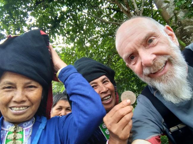
Everyone’s happy because I bought an old French coin.
As I rode further into the hills the ethnic groups changed again. Gone were the buns and the odd crash helmets. The women now wore scarves around their hair and necks, clearly for warmth. But the biggest change was in their dress. They still wore heavy blouses and jackets but along with them they wore very colourful, pleated circle skirts. Beneath those they wore heavy leggings, sometimes decorated with ribbons. The design and pattern would often change in subtle ways as I rode through different villages. On top of a hill I came to an open area next to the road, where women were selling fruit and vegetables. Set back was a building, selling drinks and so on. A group of girls was sitting there so I bought a drink and some biscuits. I shared the biscuits with them and then managed to get more good photos. They were happy to pose for me.


The last part of the ride, into Sa Pa, was a bit different. The town sits at nearly 2,000 metres. The road up over the pass was busy with trucks, and then the mist closed in. I kept expecting to come out of it, but didn’t – for two days! Sa Pa is a very busy tourist town, the advantage of that being that I was able to find a nice hostel at a good price.
On the way to Sa Pa I’d been in contact with Peter, my Polish friend from Malaysia. I’d expected him to meet me here but he’d got delayed. Instead I met up with Frank, a German traveller who I’d contacted via Facebook. We enjoyed an evening of Pizza and beer, chatting about travelling. He’s been around most of the world and has explored SE Asia extensively over the last twenty years. He managed to buy a Honda XR200, an ideal bike for Vietnam. We had a great evening and agreed to meet the next evening, when Peter would be here.
Next morning the town was still shrouded in thick mist. I suppose I shouldn’t have been surprised given that the town ‘enjoys’ 160 misty days per year. But it was very frustrating all the same. I could sense there were some good views to be had. I wandered around the town, mingling with the other tourists and the multi ethnic locals, many of the women trying to sell woven goods. I found a museum relating to the six different ethnicities that live in the area. It displayed a lot of their woven hemp cloth, each tribe with different patterns, as well as telling the historical stories.


One reason why Sa Pa is so busy is because it provides access to Fran Si Pan mountain, sitting at the tail end of the Himalayas and Indo China’s highest mountain. The Sun Group, a huge Vietnamese company, had recently completed a two kilometre mountain railway, which links up with the cable car system that goes to the top of the mountain. Guess who owns the cable car link? Impressive though the Swiss built carriages may be, I was far more amazed by the idea of the six kilometres of cable car. That strikes me as a long ride. The problem is that there’s no way of telling what the weather would be like on the mountain top. It might have been bright sunshine, up above the clouds, but at over £21 for the fare, I wasn’t going to take the chance.
After another good evening, with Peter and Frank, I woke up to bright sunshine. It would have been nice to have stayed to explore, but I had to move on. Frank was also leaving so we rode together for a while before parting ways. My loose plan was to head to Hanoi but with some diversions too. One of these was a loop road that wandered further up into the hills into an area that was surrounded on three sides by China. I was heading for the Flagpole at Lung Cu, notable for being the closest accessible point to China. It was likely to be the closest I’d get to China on my bike so it was worth the trip.

Deep ravines and green rivers.
The first part of the road was really rough. A mostly stony surface, but which eventually smoothed out. Then it became spectacular. The road twisted and climbed, giving fantastic views over the valleys below. Snaking rivers along the bottom, or roads snaking up the hillside. The hillsides were all terraced; sometimes with rice paddies, other times with different crops. Stopping to admire the view, I found myself chatting to other westerners, who’d hired bikes to make their own tours, or waving at them as I rode by. This was a popular area, that’s for sure. As I climbed higher the terrain changed into bare, treeless rock. Steep slopes with tumbled rock but no vegetation. It looked like land under formation, although this landscape was over 500 million years old. It had been damp earlier but the sun was out now, making this ride a real treat.


I arrived at the Flagpole and discovered a bunch of other riders there, all on big road bikes. E.g. Harley, BMW R1100RR, Ducati Scorpio, and similar. It must have taken a fair bit of skill to get those bikes over some of the rough sections of road. I was impressed. Among them Was David, a Scottish guy with his Vietnamese wife, and a long term Vietnamese resident. He explained they’d all travelled up on the train from Saigon to Hanoi, then rode out from there. We enjoyed a good chat, with several of the others speaking English too. Lots of photos, then we climbed the 270 steps up to the Flagpole and its viewpoint. The actual border is 3.3kms away, so we dutifully gazed across toward it. The plate on the base declared that, at 23o 22’59”, we were still inside the tropics by a measly 7 minutes. I had my coat on and it definitely didn’t feel tropical.

A bit of Vietnamese identity and pride. The flagpole at Lung Cu.
I was invited to stay with this friendly mob and we found some hostel style accommodation in the nearby village. There were several similar buildings, all recently built. We learned that having built the Flagpole in 2010, the authorities had provided building grants to nearby villages so they could earn income from the tourist influx. Sensible investment into people’s independence by the government. Among the other visitors there was a documentary team there, making a film about the Flagpole and surrounding area. Another boost to tourism. I was impressed. My new friends paid for my food, including next day’s breakfast, and David shared his bottle of red wine with me. I really like these chance meetings.

Escapees from Saigon. Lovely people.
In the morning, once the rain had stopped, we were planning to ride back down the hill but a visit to the Bamboo Village was suggested. So we headed off down a rough track, which eventually became a smooth, new concrete path. Eventually it came out to another monument which was even closer to the Chinese border. There was a small building up some steps, a car park and a visitor centre (albeit closed). China was just on the other side of the ravine. Given all the fuss about the Flagpole monument, who had this one been built for, obviously with official backing? How odd. We never did find the bamboo village and headed off down the hill. At the junction with the main road I said my goodbyes to a great bunch of people and we disappeared into the mist on our respective journeys.
I was still high up and when the sun eventually drove the mist away I had some stunning views to enjoy among the karst hills. Eventually I came into a village where I saw what looked like an impromptu cattle market taking place on the outskirts. This was notable because ordinary cattle seemed to be rare in these parts, water buffalo being the beasts of choice. The riding had been a bit challenging during the morning and I used that as an excuse to enjoy cake and coke. I needed the energy!


I was heading for the coastal town of Ha Long, from where I could get a ferry out to Cat Ba island. Easy riding now, despite the very busy coastal road I decided to take. After a night in a hotel I got on the ferry for a very nice cruise through hundreds of tall, jagged karst islands. Quite spectacular as ferry journeys go. I got chatting to three guys from Melbourne, Pete,Craig and Oz, who were touring round on rented trail bikes. Oz had a broken clutch cable so once we’d docked I dug out my spare emergency cable and fitted it, amused to find that the broken one was also an emergency one. We had a great chat about all things travelling. Oz offered me money for the cable knowing, I think, that I’d refuse it. I’d had so much help on the road that it was great to be able to pass it on.
Cat Ba island is not far from Hanoi and is a holiday centre for both locals and foreigners. It’s not a big place, with its one main town on the coast. There were a few places to visit, the first being the Hospital Cave. A cave, but much more than that. Spread over three levels, this is a real feat of engineering. Dug into the side of one of the karst outcrops during the Vietnam War, it contains a large number of wards, operating rooms and accommodation. Included is a swimming pool and a cinema, as well as some offices for the Viet Cong leaders, who used it as a safe house. Some of the cave is natural but most of it seemed to have been dug out, judging by the concrete lined walls. The entrance is almost invisible from the outside and it can’t be seen from the air. The ticket price included a guide, whose English wasn’t great, but who managed to explain everything to me.

Forever on duty, with their rusty gun.
I found a nice hostel in the town, overlooking the sea. Nearby, but up a steep hill, was the Cannon Fort. I huffed and puffed my way up there and had a look around this fortification, built by the Japanese in 1942. Needless to say it was adopted by the French, then the Vietnamese after the French had gone. The PAVN used it as a defence against invasion although I don’t know whether any of the guns were ever fired. Two of the gun emplacements have been preserved, one of them being ‘populated’ with mannequins dressed in PAVN uniform. There was a signed path, which walked me through the displays of buildings, trenches and the odd tunnel. Perhaps the best feature of the fort is the views. At 177 metres high, there’s a terrific view across the island and, more especially, out across the bay. Cat Ba is the largest of a grouping of over three hundred karst islands. Down below I could see rows of fishing boats moored in colourful rows. By glancing off to one side I could see the tourist boats, either moored or heading out to sea. The three Aussies were going on an island hopping, overnight voyage, a common choice among tourists. I didn’t have the time to do that, what with my quickly expiring visa to think about.

One of the views out over the bay.
Cat Ba is, I read, Vietnam’s number one destination for adventure tourism too. Kayaking, diving, rock climbing, to name just a few. The centre of the island is a national park, so hiking and biking is popular. This explains the huge number of hotels and hostels strung along the seafront, and also the number of mostly young western tourists there too. The ever busy Sun Group is busy building a huge marina and yet more hotels. On the way back from the fort I called into a café and got chatting to the rider of a rather nice looking, café racer style Honda CX400. He was English and he’d come out here as a tourist but stayed to run a business. This was a fairly common occurrence out there, I discovered. It’s counter intuitive to think of a communist country being so open.

A very neat little café racer.
I got chatting to some girls at the hostel and they insisted I join them at a place that had free beer. Although it was a noisy disco bar I enjoyed it, and the beer of course. A 2am bedtime told the tale. So it’s no surprise that it was 11am before I left and headed over to a different ferry, one which took a shorter route but delivered me to the road for Vietnam’s capital, Hanoi.
Tales of the city coming soon.

Noodle soup. You never know for sure what’s in there, but I’ve never had a bad one.

Lots of Westerners hire scooters and enjoy these hills.

There’s always the risk of landslips up here.

I reached 50,000kms in Cat Ba.
