
Jorhat, Assam, India. 28th December 2019.
With Guwahati behind me I rode up the hill on the dual carriageway out of the city, and then turned east. This road was also a dual carriageway so progress was good and smooth. I stopped for fuel and had the usual efficient service from the people there. In India I’ve been pleased to find that the pump jockeys always understand the request to “fill the tank”. At many other places in Asia their focus is on putting in a round figure of the local currency and will often set the pump to stop at a predetermined amount. I get very frustrated by this because I want the tank full to the brim and it’s never enough. It means I have to insist they start the pump again and keep the fuel flowing until I’m happy. I remember one occasion where, after this had happened twice and it still wasn’t enough, the young woman stormed off and asked somebody else to finish the job. Most customers just want a fixed amount in their small bikes. Long distance travellers frustrate the system. In India they give me a printed receipt too, which makes my record keeping very easy.

A self feeding elephant, carrying its dinner.

The Big Five.
Soon after the dual carriageway had ended I entered the Kaziranga National Park. This is a very impressive place. The first thing I saw was an elephant, probably my favourite animal these days, walking along the road with a mahout on his back and two more people behind. On its back it carried its dinner. A big bundle of vegetation which, it seemed to me, it was itching to enjoy. The road signs declared that it was an animal corridor, which explained the frequent road humps, usually four at a time. There were signs advising tourists that the park was home to India’s big five animals, which appear to be rhinos, tigers, elephants, buffalo and swamp deer. I stopped at a couple of viewpoints and at the second I was able to see a rhino, way, way in the distance. I took a photo of this grey blob, just to be able to say I’d seen it.
This is a very well managed park. The signage was plentiful along the well managed road, and the information boards at the viewpoints lived up to their name. I learned that the park had raised areas throughout, designed to give safe haven to the animals when the seasonal floods arrive. There is accommodation within the park, from where visitors can take tours around to see the animals.I suspect that seeing a tiger would be rare but the others ought to be easy enough. I expect to revisit that area sometime and I may well treat myself to a safari. Further along the road I passed by two elephants, stood in the middle of the road, with the mahouts collecting donations from the passing cars. It was impossible for them to get past until they’d made a contribution but for a man on a motorcycle, not so difficult.

Rhino, disguised as grey blobs.
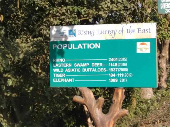
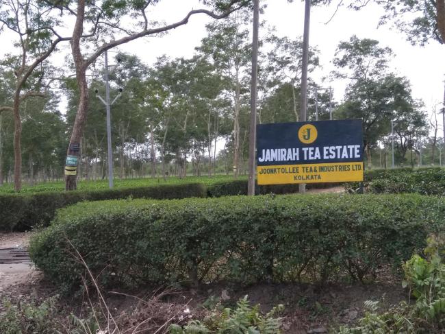
These numbers suggest a successful enterprise.
Once the good road had finished I hit a long section of broken up asphalt – the worse surface to ride on. And it went on for a long time as well. But eventually I got to my destination and booked into an overpriced hotel. It was when I was coming back from getting something to eat that I noticed my number plate was missing. Damn those rough roads!
Next morning my unidentifiable bike and I carried on eastwards, still shadowing the Bhramaputra River. The ride was unremarkable but I was interested to see how much more rural this area was. The land, being close to the river, was very fertile although not all of it was in use. I’d tended to think that in a crowded country like India every square metre of land would be ploughed and planted. Not so. There were large tracts of what seemed to be native trees and bushes, not used for anything. A good thing, of course.
Once in the town of Sivasagar I found the usual ‘cheap as possible’ hotel that I normally use and then went for a walk around. There was nothing very attractive to see until I walked down a side street that led to what was described as Sivasagar Town. The road was lined on one side with small, but neat houses behind which was a body of water. The map showed it to be triangular in shape, so clearly man made. As I looked past the houses I could see some very tall, reed-like plants growing up. I presumed they were planted in the water behind the houses but I couldn’t see well enough to know. And I never did find out either. Was it cultivation or just nature? But it added a little bit to my store of knowledge about the local area. A couple of days later, when out on a ride, I saw more of the same, so obviously cultivation.

The station building has echoes of older architecture from the region.
At the end of the road was not a town as I’d expected, but the railway station. Indian station buildings always look nice. Often built during the colonial era, they tend to be graceful and stylish, despite their functionality. This one had echoes of the local architecture and I walked through to the platform just as a train arrived. I’ve always liked trains and I was pleased to admire the big diesel/electric locomotive, looking serene in its ability to haul the twelve carriage load.

We all like a big locomotive. Diesel electric in this case.
Sivasagar had some sites worth visiting so I stayed there a few days. The city gets its name from the big lake built by the Ahom people, who ruled the area now known as Assam for six centuries. The city was their capital for about one hundred years until the kingdom fell to the Burmese in 1819. The whole area was then taken over by the British in 1826. The Sivasagar Tank, as the lake is called, sits in the heart of the town. It’s big, with each side being at least a kilometre long, and is about ten metres deep. It maintains its level all year long, demonstrating the advanced building and engineering skills of these old civilisations. It supplies the town’s water needs all year round. Along its sides are various temples, both Hindu and Buddhist, as well as mosques and the Tai Ahom Museum, which tells the story of the Ahom people. They were ancestor worshippers at first, having come from south China. But over time they adopted Buddhism and then Hinduism. Once again, this same story is spread across much of the northern areas of these east Asian countries.
During the 18th century they moved their capital to Sivasagar and seemed to spend all their time building – or digging. The legend is that the tank was dug out in one night. Given that I estimate it to have a volume of fifteen million cubic metres, they must have had a lot of people with some very big shovels. As well as the Tai Museum, there is a park which contains some Hindu temples. The biggest one is the Sivadol (Shiva Temple). It was built on the orders of the Queen in 1734, along with two smaller temples. One is dedicated to Vishna and the other to Durga. Their design is similar to the Sivadol which has, at 32 metres, the highest dome of any Hindu temple in India. I didn’t try to get inside as it was very busy but a walk around the outside showed how carefully it had been built. from stone and brick. The building technique is described as organic because they made the mortar from powdered rice and ducks eggs. All around the outside were bas-relief sculptures and carvings of various gods, many of them of a unique design. They were all surrounded by nice gardens and, with the lake in the background, made a very pleasant place for the faithful and the curious.

Sivadol Temple. Highest Hindu dome in India.
Whenever I get to these places I always search the internet for info on what to visit. So next day, armed with a list, I took a ride around to see the sites. I visited two more tanks, a little further out of town. It’s clear that when these have been dug out people move near to them, build villages and also temples. The river runs nearby and I imagine that’s where the water comes from. It’s then used for the rice paddies. The route to the first one took me down a narrow road with market stalls on each side. As I came to a corner a small truck came towards me. I stopped but as it squeezed past me it caught the corner of my pannier and pushed me over. I had visions of me and the bike ending up among the apples, oranges and grapes, but that didn’t quite happen. Willing hands helped me to pick the bike up and I carried on. I rode down the track by the tank, seeing local people clearing the weeds out, with others out on the lake fishing. The village alongside it looked to be very dilapidated although there was a nice, but small temple nearby. This was another large tank, about one kilometre square. It was dug out in just forty five days in 1697 – a far more realistic claim than doing it in one night. The second one I visited was a little smaller and had a college alongside its banks. Generally greener and more countrified, there were also temples there too.
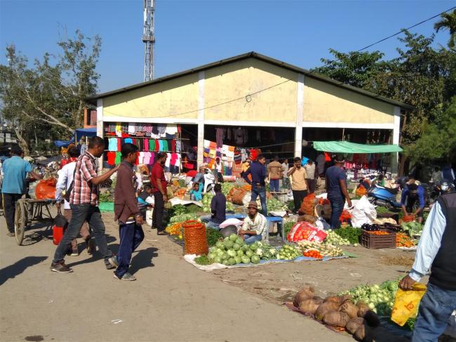
Street market for fruit and veg, where I nearly became part of the display.

Weedy water, but a pleasant place to be.

This sign was beside the tank but I saw similar signs in many places in India.
Two tanks are enough for anyone and although there were more I could have visited, my enthusiasm for tanks had, erm, tanked. So I went to look at some buildings. The rulers of the Ahom clearly had a good eye for architecture and definitely liked pink. Stone, bricks and render were all pretty much the same shade. First off was the Talatal Ghar, one of the royal palaces. It follows the Mughal style and was completed in 1769, an eighteen year task. In terms of looks I would describe it as purposeful more than anything else. Interesting architecture but not at all remarkable. It has seven stories, three of which are underground, with no access that I could discover. The lower floors are a series of chambers, the upper floor is full of rooms with passageways between them, accessed by doors that are so low that you have to bend almost double to walk through them. Some of the rooms had little alcoves built into the walls, presumably used for storage, or perhaps lamps. The outer area was formed of a long terrace, with several buildings along it. At least one temple was among them. Archaeological digs have revealed evidence of wooden buildings in the grounds too. Cannons were housed there so it was a place that was designed to be defended. A couple of things that underwhelmed me were the lack of info boards – there was just the one near the entrance – and the fact that Indians paid Rs25 entry, foreigners paid Rs300. That really, really annoys me and I found it to be the case almost everywhere.

Canons outside the palace.

This really annoys me!
As I rode away I spotted a sign for the Uttaran Museum. Museum? Take me to it! Housed in a very stylish building, it was full of ancient artefacts from the Ahom period, along with more modern items, such as old radios and telephones. Uttaran is a word in Assamese that refers to something that is worn out, past its useful life. It was put together by a local man named Durlav, and he came out to chat with me. I think the guy on the door had told him he had a visitor from London. Sounds impressive, but it was only me. He managed to hide his disappointment very well! It was a nice place to look around for ten minutes, but that was all.

Uttaran Museum. A nice building.

The guy who curated it. Older photo behind him.
Another nice, pink building was the royal sports pavilion, named Rang Ghar. Two stories high and overlooking a large field. It wasn’t difficult to imagine the king, queen and their hangers on enjoying the sports and games taking place below them as they sat up on the long balcony. I liked the style of the building too, with plenty of light flowing through it.

Sports pavilion. More pinkness.
My last visit was to the main palace of Kareng Ghar. More pinkness to enjoy. Clearly the natural rock around this area is predominately of that colour. Another light and airy seven story building, with three of them below ground once more. This palace had a bit more grandeur to it than the previous one. Some nice formal gardens around it too. I always find it interesting to see these building and imagine how life must have been two and a half centuries ago. They’ve been nicely restored by the authorities and do seem to be very popular. Assam is a very different type of area to other parts of India, with its history being far more connected to areas to the north rather than the west. A different flavour in many ways.

A much nicer palace. Fit for royalty!

Stop child labour! Clearly a hidden story here.
An even more hidden story here – I hope!
Talking of west, it was now time to cross the river and head that way. I rode towards the town of Dibrugarh and the nearby bridge. The GPS was taking me along some quiet roads, often through tea plantations, with their neat rows of bushes wandering across the landscape. A bit of a cloudy day but pleasant riding. I was heading to Bogibed Bridge with the GPS getting its knickers in a bit of a twist. It decided the correct way was down a narrow road, which soon became a sandy track. Time to turn around and try again, I thought. Second attempt got me on the right road and I headed out across the bridge, which was quite an impressive piece of engineering. There were lots of people stopped at the side of the road, gazing out at the mud flats below. It is India’s longest combined road and rail bridge, at five kilometres in length. I stopped for a photo too, of course. The main reason for building it was to facilitate troop movements to the Chinese border, which has long been a military hot spot.Further on,as I came to a T junction a guy on a bike tooted his horn at me so I pulled in at a tea stall, just around the corner. We chatted and as we were talking he mentioned an Australian guy that had stayed in the town not long ago. I soon realised he was talking about Michael, who I’d spent time with in Luang Prabang, Lao. We’d had the ‘pleasure’of falling off his bike together. He’d been in the town for three months, waiting for parts. Roy and I chatted and drunk tea before I headed off on my way. That was a real coincidence, especially as I remember Michael telling me about his time there, even suggesting a place to stay should I need it.

Roy and me.
Me, in travelling mode.
As the afternoon wore on I came across a decent looking hotel, so pulled in. I managed to talk the price down by 50%, from Rs1200 to Rs600, so felt very pleased about that. The owner came out to look at my bike and noticed my lack of number plate. He said he’d be able to get another one for me. Bear in mind this was new year’s day, I wondered how he’d manage that, but I was happy to let him try. The only fly in the ointment here is that he wanted to ride my bike to the shop. I don’t like the idea of others riding my bike so wasn’t happy about this but felt obliged to agree. He was gone about an hour but came back with a small, white plastic number plate mounted on the back and the reg number also stuck onto the front screen. Indian bikes have front number plates so I guess he felt the need to do this. By the time I’d paid him for this service I’d spent the original room fee of Rs1200!
Next day I continued heading west. I stopped for some lunch at about 1pm and thought I’d take a photo of my new number plate, just because it was a novelty. It wasn’t there! Either the bolts hadn’t been done up tightly enough or the rough roads had shaken them loose. All that effort for nothing, and I still had no number plate. At the town of Nagaon I managed to find a hotel that had somewhere secure to put the bike and once I’d got organised into a room I went looking for another number plate. The street where the hotel was also had lots of bike shops, so it didn’t take me long to find one, which quite surprised me as I’d expected it to be difficult. “Front or rear?” the guy said. Easy as that. But … I still needed the actual numbers and letters. He directed me towards another shop and in the end I came back with a new plate. I cable tied it to the bike, as a temporary means of fixing, then enjoyed a pizza in the restaurant, feeling quite pleased with myself. I celebrated with a beer. A Budweiser at that. But it was 0% alcohol and I can tell you that such a drink is the true definition of that phrase, ‘an exercise in futility’.
I saw plenty of these as I rode around.
I’d been having some online chats with Steve and Amelia, my companions from Myanmar. They were stuck in Shillong, waiting for bike parts to arrive from Australia. The hassle they were having with Indian customs made my efforts to get the parts I’d been waiting for, back down in Imphal, look like a walk in the park. I won’t bore you with the details. Suffice to say they were fed up and wanted a change of scenery. The upshot was that we agreed to meet at a place called Cherapunjee, a famous and beautiful area south of the town. It was about six hours from where I was staying, so an easy day’s ride. The making of this plan threw off the last vestiges of the Christmas lethargy I’d been suffering from back in Guwahati. It also made for me the decision as to where to cross into Bangladesh. We’d be only forty kilometres from the border at Dawki.
It was raining next morning, the first I’d seen in quite a while. But the morning route was dual carriageway so it didn’t matter much. I skirted Guwahati and found myself back on the hill, this time heading up rather than down. Although the rain had almost stopped I could feel the slipperiness of the road beneath my tyres, so caution was the watchword. The message was reinforced by the sight of a small truck lying on its side on my side of the road. It had clearly lost control on a bend as it came down the hill. By the time I came past the reservoir near Shillong, the rain had gone and the roads were dry again. But it was getting colder too and I was very glad of my heated handlebar grips.

He overcooked the bend, is my guess.
Michael had visited Cherapunjee too and had recommended a guest house too me. I’d given the address to Amelia and we planned to meet there. Cherapunjee sits on top of the hill and the tiny village of Tryna is way down in a valley. It was a very nice ride down there, with a couple of viewpoints to stop at, from where I could admire the scenic delights of the clouds floating below me but above the very steep sided valley I was riding into. The last part of the road was very narrow, very steep and very badly surfaced. I spent most of the ride down it wondering what the ride back up was going to be like. Bloody difficult, in a word. I found the guest house and soon after, Steve and Amelia arrived too. The owner was a very nice man, who made us tea with biscuits for us to enjoy while we chatted and caught up on our news.

Being above the clouds, while still on a road, is a strange feeling.
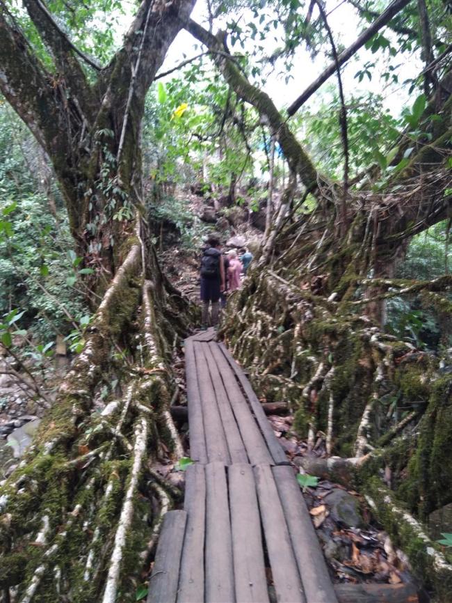
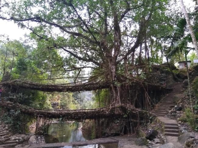
Of course you’re wondering why we schlepped all the way down into this green, cloudy and remote valley. And the answer is bridges. A very specific type of bridge. Bridges made from tree roots, in fact. Now, I’m aware that these naturally made bridges can be found in various places in the world, but we’d never seen any so were quite keen to do so. Our plan was to walk down there, and back, next day. Then stay another night before leaving. But that plan was blown out of the water when our host told us our rooms had been booked for the next night. But he also told us there were guest houses near the bridges. So we revised our plans accordingly. It turned out he’d done us a real favour because we would not have got the benefit of the visit there if we’d only had the one day.
More efforts to help the rural poor.
We were able to leave our bags and bikes at the guest house so next morning we set off down into the valley. It was a short walk to the top of the steps, with 2,500 of them between us and he valley bottom. Yes, you read that right. And every step down meant that same step had to be climbed up later. No Stannah stairlift or funicular railway to rescue us here, only leg power. But it was a nice day and coming back up was a worry for another day. Once at the bottom we crossed over an iron suspension bridge and then climbed up and down the next series of steps that took us to the very small village, where the home stays were located. We crossed a second iron bridge and then the first of the root bridges on the way. Once in the village we took a look at several places and eventually chose Serene Homestay. With a lounge/dining area that looked across the steep valley to the hills on the other side, and a good selection of rooms and dormitories, it turned out to be the ideal place. There was a young Dutch couple, an older English couple and a young Indian guy also staying there. They even had a mobile phone signal too, allowing me to peep over the top of this deep valley and see the rest of the world. The host was a great guy, who’d make tea or coffee for us and also had a constant supply of small cakes to nibble on.
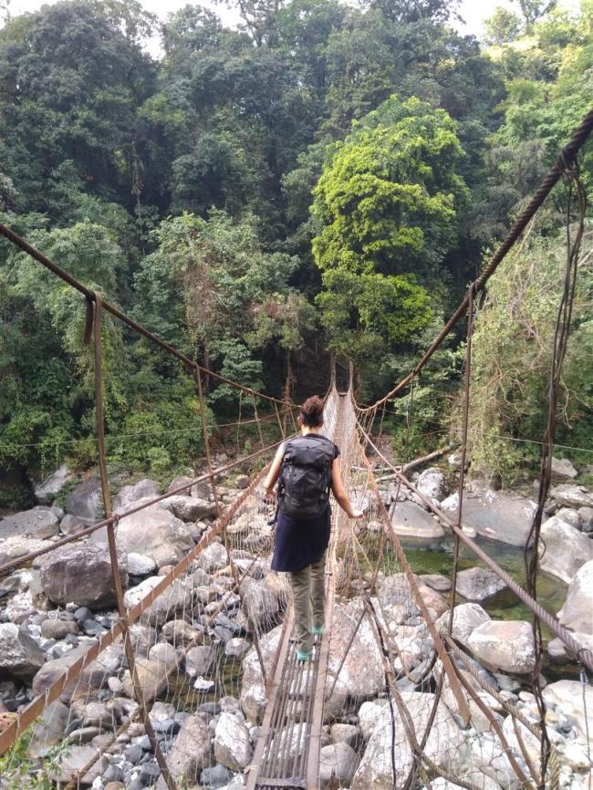
A narrow iron bridge on the way to the guest house.
Some background on this phenomenon. Cherapunjee is more correctly called Sohra, home to the Khasi people, and has been known to be the wettest place on earth. Over one twelve month period in the 1860s there was more than 26 metres of rain, although 9 metres is more the average these days. The monsoon rains are pushed northwards across the Bangladeshi plains and when they hit the 1400 metre high Khasi Hills they quickly dump their load of water onto the steep hills and deep valleys below. And yet the area suffers from a lack of potable water. The reason is that human encroachment into the forests have destroyed too much of the top soils.
Not just the bridge but the handrails also formed from the roots.
What about the bridges? They are formed from the roots of rubber fig trees, which can grow easily on the steep slopes next to the rivers. The above ground roots are trained to grow across the river, their elasticity making this entirely possible. Between ten and fifteen years is needed to grow a bridge. The roots will continue to get thicker and will intertwine over the years. They are more than happy to root themselves into the ground on the opposite bank and if two opposite trees have been used then the roots will join together in a process similar to grafting. When strong enough, boards are laid across them. Install a handrail and a bridge is created. The bridges we saw were about twenty five metres long and were made from a single tree. But the longest known bridge is fifty metres. They were formed by hand, the local people having trained the roots to grow across the river. But other methods were used elsewhere, such as by using bamboo scaffolding. The oldest known bridge is reckoned to be five hundred years old. They can be found elsewhere in India, and also in SE Asia. More information here.

Double decked root bridge. You wouldn’t think it possible, would you?
Once we’d unpacked we walked the short distance to see the main attraction, the Double Decker bridge. This astonishing example of tree root weaving has, as the name suggests, a lower and an upper deck. It seems that flood waters washed over the lower deck, too deep and too often, so the obvious solution was adopted, to build one higher up, about three metres above. Same methodology with the same result, each bridge created from one tree. We had a bit of silly fun while taking photographs, with Steve and Amelia marching back and forth, one above and one below. There had been a pool constructed below the bridges so we were able to scramble around and get some different angles for photographs too. Apart from the bridge itself, the whole area was great to be in. Green, rainforest clad slopes, a busy river, moss bedecked rocks, ancient trees and all the natural beauty such places have. There was an eerie feeling to these bridges, as if the trees had come alive and decided to get involved in human affairs. But it was all very good for the soul and seemingly a million miles away from the busy Indian cities.
It’s an almost perfect place to sit and contemplate the meaning of life.
We found a café near to the homestay where we enjoyed real coffee and some snacks. Suitably refreshed we walked back over the bridges to see some waterfalls, a bit further along. This was followed by a very pleasant evening, of good food and chat with the other guests. Resting from our exertions, I figured that all those steps were worth it, although I reserved the right to review that opinion when we walked back up.
Next day, after a lazy morning, we headed out to Rainbow Falls, about three kilometres away. It doesn’t sound far except that the trail wandered up and down the very steep hillside. We first crossed another iron bridge, then a root bridge made from two trees, one each side of the river. Then came the steps. Not the nice, regular concrete steps we climbed before. Oh no. These were cut into the ground and involved scrambling up rocks, over tree roots and along rocky paths. Steve forged on ahead, Amelia and I lagged behind. But we got there eventually and came to a place high up above the falls. Steve had already scrambled down to the pool below the falls and was swimming in the freezing water. Amelia went down to join him. I had the good sense to watch them from above. The waterfall looked nice but the flow wasn’t especially strong. Worst of all, not a rainbow to be seen! But it was worth the walk as the scenery and natural features were all worth the effort.

Rainbow Falls. Disappointing at this time of year. Not much water and no sign of a rainbow.

A variety of bridges to cross on the way back.
Next morning we paid our bills and set off. Steve forged on ahead, preferring to travel at his own pace. Amelia and I left soon after and enjoyed the walk back to the bottom of the steps. At this point I started counting, my plan being to rest after every one hundred steps. We had an occasional longer stop but got through it all and finally reached home base. I can confirm that there are, indeed, 2,500 steps.

Steps. And plenty more above them.
A quiet afternoon and evening of rest ensued. We were chatting and, drinking tea. We all agreed that staying down in that magical place for two days had been well worth doing and that the peace and beauty of the valley had set us up for whatever lay ahead. In Steve and Amelia’s case, their continued battle with Indian customs. For me it was all about the next stage of my journey. Bangladesh was forty kilometres away, down at Dawki. I’d shaken off my Christmas lethargy, my batteries were recharged and I was looking forward to the challenges of my thirtieth country of this journey.

More efforts to help local people.

Was nice to see a rhino – even if it just came up like a small grey dot 🙂 I am actually surprised there were so many rhinos in the park I thought the Indian rhinos were very rare.
LikeLike
I hope to go back there before I leave India and have a tour round the park. Look out for a better photo, one day!
LikeLike
Good luck ☺
LikeLike
India is so interesting. The grey blobs are convincing. And I thought for a minute you were going to say you had another injury from the tumble off the bike.
Love the bridges, how interesting and very clever.
LikeLike
The north eastern part of India is very different from the rest. But in many ways all areas of India are different from each other, as I’m discovering. Glad you enjoyed the write up.
LikeLike
Thanks for linking in to my blog. 🙂
LikeLike